


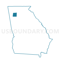
01515 - WHITE Voting District, Bartow County, Georgia
About
Outline

Summary
| Unique Area Identifier | 560305 |
| Name | 01515 - WHITE Voting District |
| County | Bartow County |
| State | Georgia |
| Area (square miles) | 45.20 |
| Land Area (square miles) | 44.93 |
| Water Area (square miles) | 0.27 |
| % of Land Area | 99.41 |
| % of Water Area | 0.59 |
| Latitude of the Internal Point | 34.29021500 |
| Longtitude of the Internal Point | -84.71190100 |
Maps


Graphs
Select a template below for downloading or customizing gragh for 01515 - WHITE Voting District, Bartow County, Georgia


Neighbors
Neighoring Voting District (by Name) Neighboring Voting District on the Map
- 01501 - ADAIRSVILLE Voting District, Bartow County, GA
- 01503 - CARTERSVILLE EAST Voting District, Bartow County, GA
- 01505 - BEAVERS DRIVE Voting District, Bartow County, GA
- 01506 - CENTER Voting District, Bartow County, GA
- 01509 - FOLSOM Voting District, Bartow County, GA
- 01512 - PINE LOG Voting District, Bartow County, GA
- 01516 - ZENA DRIVE Voting District, Bartow County, GA
- 01517 - CASSVILLE Voting District, Bartow County, GA
- 057035 - SUTALLEE Voting District, Cherokee County, GA
- 057041 - WALESKA Voting District, Cherokee County, GA
Top 10 Neighboring County Subdivision (by Population) Neighboring County Subdivision on the Map
- Cartersville CCD, Bartow County, GA (51,048)
- White-Pine Log CCD, Bartow County, GA (11,201)
- Adairsville CCD, Bartow County, GA (10,802)
- Waleska CCD, Cherokee County, GA (7,772)
Top 10 Neighboring Place (by Population) Neighboring Place on the Map
Top 10 Neighboring Unified School District (by Population) Neighboring Unified School District on the Map
- Cherokee County School District, GA (214,346)
- Bartow County School District, GA (80,433)
- Cartersville City School District, GA (19,724)
Top 10 Neighboring State Legislative District Lower Chamber (by Population) Neighboring State Legislative District Lower Chamber on the Map
- State House District 21, GA (75,926)
- State House District 15, GA (58,888)
- State House District 14, GA (58,382)
- State House District 12, GA (56,194)
- State House District 20, GA (51,632)
Top 10 Neighboring State Legislative District Upper Chamber (by Population) Neighboring State Legislative District Upper Chamber on the Map
- State Senate District 27, GA (264,822)
- State Senate District 31, GA (204,694)
- State Senate District 21, GA (171,113)
- State Senate District 52, GA (168,885)
Top 10 Neighboring 111th Congressional District (by Population) Neighboring 111th Congressional District on the Map
Top 10 Neighboring Census Tract (by Population) Neighboring Census Tract on the Map
- Census Tract 9602, Bartow County, GA (10,802)
- Census Tract 9601.02, Bartow County, GA (9,507)
- Census Tract 9604.02, Bartow County, GA (8,926)
- Census Tract 902, Cherokee County, GA (7,772)